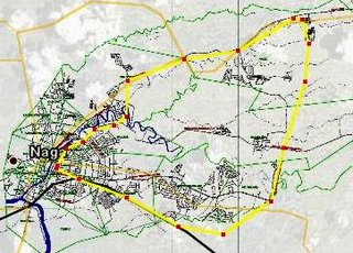
A light rail system for Naga?
INSPIRED by the work of Senen Ebio in Makati and Urbano dela Cruz in D.C., I tried my hand using Google Earth to think about one of the key questions asked towards building a livable and sustainable urban community.
How about a light rail transport system in Naga? Overlaying Naga's urban base map (emailed to me by Bob Ursua as part of data gathering for some related top-secret urban livability project) on Google Earth, I came out with this: a 20-kilometer light rail system that will connect the fringes of CBD1, and link it with CBD2 and the proposed mixed-use property development along Almeda Highway. The loop then cuts through the existing residential areas in Concepcion Grande and Del Rosario; connect them to the new emerging bedroom of the city: Pacol (the fastest growing barangay in terms of population) where both low- and high-end housing projects are rising silently; and then turn back towards the city center alongside the existing Naga-Carolina Road.
Around 20% of the network will make use of existing PNR tracks, helping bring down the cost of civil and track works (assuming of course that the railroad tracks are compatible with light rail requirements). It should also be electricity-powered to ensure environment-friendliness, and protect operating costs from instabilities that will continue to attend petroleum prices.
The question is: Will such a system be economically viable within the next 10 years? A feasibility study will give us a definitive answer. Those who are interested about the kind of costs involved can check this.
A local LRT system can very well be a pipe dream. But then again, why not? :)


3 comments:
why not?
I think you should definitely go ahead with the feasibility study. To reduce startup costs, I would suggest looking at Bus Rapid Transit first -on a dedicated busway -but make sure the civil works will accomodate a surface light rail/trolley in the future.
A BRT investment will cost a fraction of light rail - and light trolley on fixed guideway (surface tram) is easy to deploy -and is just the third of the cost of elevated rail. The tracks can be laid down in less than a year.
One key thing is to make sure your land use plan informs your transportation plan. the worst thing that could happen is to put the mass transit away from the densest areas -where the commuters are.
The bigger challenge is to get public transport operators (and drivers) to go along with the project. In my ideal world -the municipal BRT should be operated (on a leasehold) by a transport cooperative. Maybe you can transition the operators and drivers from simple proprietorships to managing and running a corporation.
Thanks, Urbano.
In fact, a ground level rail system is what I really had in mind, not the elevated ones like LRT or MRT. (Saw a picture in one of your previous posts, in fact.) Did not know it's called a BRT. :)
And your point regarding getting public transport operators is indeed critical. I just tested the idea with Mayor Jesse, and off the cuff, he emphasized the need to minimize negative impact among our existing transport providers.
Previously you asked aloud in what ways can you help Naga. I find our ongoing conversation a great help already. Your experience and expertise on local urban development issues, using blogging as medium, would be a great way to start.:)
[url=http://wholesalenfljerseysv.webs.com/]wholesale nfl jerseys[/url] [url=http://wholesalenfljerseysv.webs.com/]wholesale nfl jerseys[/url] http://wholesalenfljerseysv.webs.com/ I really like this particular handbag, this is just the main one I want!
Could not think how quickly a person shipped this particular! Great product. Thank you!!!
I had been happy along with my purchase as well as every thing came directly on time, many thanks!
Extremely vendor with quality, good support as well as communication. Extremely fast shipping, exactly as described and pictured, excellent item, very happy!
Post a Comment