Google Earthing a better route for the Naga marathon
 I WAS standing near the Universidad de Sta. Isabel gate nearest to the Metropolitan Cathedral when the three waves of participants in the Naga qualifier for the 30th Milo Marathon passed by. Blessed by a delightful morning, the organizers have every reason to be happy for the huge turnout, except for the many motorists, jeepney and tricycle drivers as well as their passengers who were terribly inconvenienced by the event. Not to mention the churchgoers who chose to be at the Cathedral that morning.
I summoned Google Earth the moment we came back home from our own Sunday church meeting and fortunately enough, it worked notwithstanding my dialup connection. (All along, I thought it only works with DSL.)
Plotting the route my son took for their 5K run (see top map), I readily understood why: the route went through three main traffic generators — the plaza, the cathedral itself and the Bagumbayan-Liboton intersection (airbrushed in blue, courtesy of Microsoft Paint). Add to it the fact that it is a major thoroughfare connecting Naga to the Tinambac-Calabanga-Bombon-Magarao area, there was simply so much the Naga police and Lito del Rosario's Public Safety Office people were up against. It was a situation ripe for an accident. And Tox Ballaran, whom I chanced upon this morning, told me an accident indeed occurred last year.
So why not come up with a better route that skirts traffic generators, thereby minimizing potential bottlenecks and the possibility of accidents? Initially, I thought having it begin and end at the City Hall complex might be a good idea. The entire stretch of Juan Miranda Avenue all the way to the Bicol Medical Center can accommodate even twice the number of people who showed up this morning. The downside however lies in its distance from the city center, and the probable sparse crowd that Nestle will not want for that event. Even then, it is still a better option, safetywise.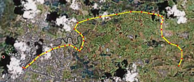 The bottom map is another alternative. It starts and ends from the Plaza but passes through Blumentritt all the way to Balatas, then turns left to San Felipe (via Almeda Road, not the Highway) at the Gualandi Center, all the way to Pacol, then towards Ateneo de Naga High School where 21K marathoners would turn back at the Avida rotunda. Each way, this route would be roughly 10 kilometers.
It is better because (1) traffic on the Naga-Carolina route is thinner than that of Naga-Calabanga; (2) closing off the entire Blumentritt Street is possible as Dayangdang-bound vehicles can be rerouted elsewhere; (3) Carolina and Pacol-bound PUJs can be rerouted through Cararayan via sitio Salonguigui; and (4) the event will continue to start and finish at Plaza Quezon, thereby maintaining maximum media value.
And the safety of the both the serious and occasional Milo marathoners, which should always be paramount, will be better assured.
![]()


5 comments:
give the milo folks and naga city trafic boys better city maps next time.
btw, congrats to your Ezekiel. well done.
They will have, but they need to appreciate Google Earth first:)
Very cool design! Useful information. Go on! » »
Best regards from NY! » »
Excellent, love it! Truck laptop holders Kids with toys Wu long tea weight loss electric wheelchairs africa travel Used blackberry car charger cell phone North dakota sterling tattoo removal Replacing ford taurus air cleaner Fundraising web site templates Parfum fragrance Riverside ca standards for the teaching profession bingo game
Post a Comment